Aug 19, 2026
The Shipping Forecast Explained: How to Read It and Use It
Richard Beniston


The shipping forecast is a 24 hour marine weather bulletin produced by the Met Office for the Maritime and Coastguard Agency, covering 31 sea areas around the British Isles and broadcast on BBC Radio 4. Each bulletin comes in four parts: gale warnings, a general synopsis of the pressure systems, forecasts for each sea area, and, on the longer broadcasts, coastal station reports and an inshore waters forecast.
Every area forecast gives you three things in a fixed order: wind direction and force, weather, and visibility. Once you know that order, and know that words like "imminent", "soon" and "later" are measured from the time the forecast was issued rather than the time you heard it, the whole thing becomes readable.
This guide covers the sea areas in the order they are read, what every term means, how to decode a real bulletin, and which forecast you should actually be using for coastal sailing in the UK.
About the Author
Richard Beniston is an RYA Yachtmaster™ Examiner for sail and power, an RYA Yachtmaster™ Instructor and one of 22 RYA Instructor Trainers worldwide. He holds RYA/MCA Yachtmaster™ Ocean and teaches the shorebased theory courses at Sailing Course Online, alongside working as an SRC radio assessor and Sea Survival instructor. Over 23 years he has skippered yachts across much of the world, run his own training centre, delivered luxury yachts across the Atlantic and skippered in three Fastnet campaigns and a long run of RORC racing.
Learn more about our instructors
What is the shipping forecast?
The shipping forecast is the marine weather forecast for the seas around the British Isles, produced by the Met Office on behalf of the Maritime and Coastguard Agency (MCA) and broadcast by the BBC. It covers 31 named sea areas stretching from Southeast Iceland down to Trafalgar off southern Iberia (Met Office, 2026).
It marked 100 years on the BBC in July 2025, making it the longest running continuous weather forecast on radio (Met Office, 2025). The same forecast is also transmitted over the Navtex system, using the same format and the same sea areas, which is how many yachts receive it on passage.
The forecast is issued four times a day at 2300, 0500, 1100 and 1700 UTC, and each bulletin covers a 24 hour period beginning at 0000, 0600, 1200 or 1800 UTC respectively (Met Office, 2026). Those issue times matter more than the broadcast times, for reasons covered further down.
When is the shipping forecast broadcast?
There are two BBC Radio 4 broadcasts on weekdays and three at weekends:
| Time | Days | Contents |
|---|---|---|
| 00:48 | Daily | Full bulletin including Trafalgar, coastal station reports and inshore waters forecast |
| 05:34 | Daily | Full bulletin including coastal station reports and inshore waters forecast |
| 17:54 | Saturdays and Sundays | Sea area forecasts only |
The 05:34 slot moved from 05:20 in March 2025, so older guides you find online will list the wrong time. Several still list a lunchtime bulletin that no longer runs.
If you are ashore and planning, the Met Office publishes the current forecast online, which is more convenient than waiting for a broadcast and includes sea state as well.
The four parts of a shipping forecast
Every bulletin follows the same structure, and the radio script is capped at 350 words, rising to 380 for the 00:48 broadcast to make room for Trafalgar. That word limit is why the language is so compressed.
Gale warnings
Gale warnings come first, and only if there are any. They start at force 8 on the Beaufort scale, and the wording escalates from there.
| Term | Beaufort force |
|---|---|
| Gale | 8 |
| Severe gale | 9 |
| Storm | 10 |
| Violent storm | 11 |
| Hurricane force | 12 |
A typical warning sounds like "There are warnings of gales in Rockall, Malin, Hebrides, Bailey and Fair Isle." Sometimes it is inverted, as in "gales in all areas except Thames, Dover and Wight", which tells you a large system is crossing most of the forecast region.
Warnings are triggered on gust speeds as well as mean wind strength, which is a British addition to the international system (Royal Meteorological Society).
The general synopsis
The synopsis describes the pressure systems: where they are, their central pressure in millibars, and where they are heading. For example, "Low, Rockall, 987, deepening rapidly, expected Fair Isle 964 by 0700 tomorrow."
This is the part most people skip, and it is the part that tells you what tomorrow looks like. Understanding what the pressure in the general synopsis is telling you is what turns a set of numbers into a forecast, because a low deepening by 23 millibars in a day is a system worth planning around.
The sea area forecasts
Each of the 31 areas gets wind direction and force, weather, and visibility, in that order. Areas with similar conditions are grouped together to save words, which is why you hear "Humber, Thames" read as one entry.
Coastal station reports and inshore waters
The 00:48 and 05:34 broadcasts continue with actual observations from coastal weather stations, then an inshore waters forecast for named stretches of coastline. This extra material sits outside the 350 word limit.
The 31 sea areas in broadcast order
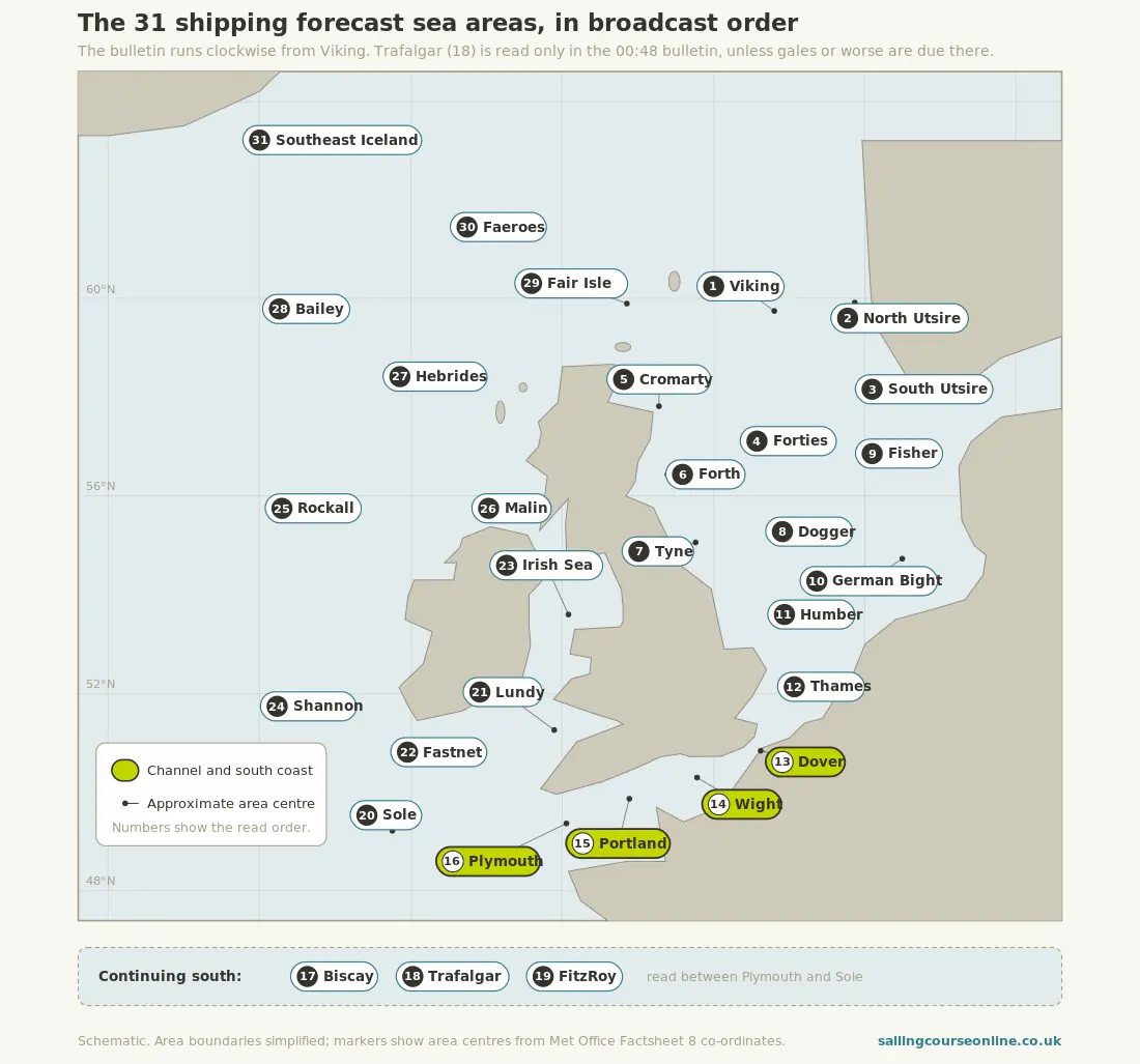
The bulletin always runs clockwise around the British Isles, starting with Viking in the northern North Sea and finishing with Southeast Iceland. Learning the order pays off, because it tells you when your area is coming and lets you listen to what is happening upwind of you first.
| # | Area | # | Area |
|---|---|---|---|
| 1 | Viking | 17 | Biscay |
| 2 | North Utsire | 18 | Trafalgar |
| 3 | South Utsire | 19 | FitzRoy |
| 4 | Forties | 20 | Sole |
| 5 | Cromarty | 21 | Lundy |
| 6 | Forth | 22 | Fastnet |
| 7 | Tyne | 23 | Irish Sea |
| 8 | Dogger | 24 | Shannon |
| 9 | Fisher | 25 | Rockall |
| 10 | German Bight | 26 | Malin |
| 11 | Humber | 27 | Hebrides |
| 12 | Thames | 28 | Bailey |
| 13 | Dover | 29 | Fair Isle |
| 14 | Wight | 30 | Faeroes |
| 15 | Portland | 31 | Southeast Iceland |
| 16 | Plymouth |
Two quirks worth knowing. Trafalgar gets a full area forecast only in the 00:48 bulletin, and the other bulletins name it only if gales are being warned there. And FitzRoy was called Finisterre until February 2002, when it was renamed after Vice-Admiral Robert FitzRoy, who set up the original storm warning service, partly to avoid confusion with a Spanish area of the same name.
For anyone sailing the Solent and the south coast, your areas are Wight and Portland, with Dover to the east and Plymouth to the west. Listening to Sole and Plymouth first will usually tell you what is heading your way.
Shipping forecast terms decoded
The forecast uses a fixed vocabulary in which every word has a defined numerical meaning. These are the sets you need.
Wind
| Term | Meaning |
|---|---|
| Veering | Direction changing clockwise, for example southwest to west |
| Backing | Direction changing anticlockwise, for example southwest to south |
| Becoming cyclonic | Considerable change in direction as a depression crosses the area |
Timing
| Term | Meaning |
|---|---|
| Imminent | Within 6 hours of the time of issue |
| Soon | 6 to 12 hours from the time of issue |
| Later | More than 12 hours from the time of issue |
| At first | During the first part of the forecast period |
| Occasionally | Less than half the time |
| At times | More than half the time |
Visibility
| Term | Meaning |
|---|---|
| Good | More than 5 nautical miles |
| Moderate | 2 to 5 nautical miles |
| Poor | 1,000 metres to 2 nautical miles |
| Very poor | Less than 1,000 metres |
Sea state
Sea state appears in the online forecast rather than the radio bulletin, and refers to significant wave height.
| Term | Wave height |
|---|---|
| Smooth | Less than 0.5 m |
| Slight | 0.5 to 1.25 m |
| Moderate | 1.25 to 2.5 m |
| Rough | 2.5 to 4 m |
| Very rough | 4 to 6 m |
| High | 6 to 9 m |
| Very high | 9 to 14 m |
| Phenomenal | More than 14 m |
Movement and pressure tendency
| Term | Meaning |
|---|---|
| Slowly | System moving at less than 15 knots |
| Steadily | 15 to 25 knots |
| Rather quickly | 25 to 35 knots |
| Rapidly | 35 to 45 knots |
| Very rapidly | More than 45 knots |
| Rising or falling slowly | Pressure change of 0.1 to 1.5 hPa in the past three hours |
| Rising or falling | 1.6 to 3.5 hPa in three hours |
| Rising or falling quickly | 3.6 to 6.0 hPa in three hours |
| Rising or falling very rapidly | More than 6.0 hPa in three hours |
The full official terminology is published by the Met Office and is worth bookmarking, though most of it becomes second nature once you have seen how weather is taught in RYA Day Skipper theory.
A real bulletin, decoded line by line
Here is a bulletin of the kind you would hear if a front were crossing the Channel, with each phrase translated.
"Wight, Portland. Southwest 4 or 5, veering west 6 to gale 8 later. Rain then squally showers. Moderate or good, occasionally poor."
| Phrase | What it tells you |
|---|---|
| Wight, Portland | Both areas are getting the same forecast |
| Southwest 4 or 5 | Wind from the southwest, force 4 to 5, roughly 11 to 21 knots |
| veering west | Direction moving clockwise, southwest round to west |
| 6 to gale 8 | Increasing to force 6, and possibly reaching gale force 8 |
| later | More than 12 hours after the forecast was issued |
| Rain then squally showers | A front passing through, with gusty conditions behind it |
| Moderate or good | Visibility 2 nautical miles or better |
| occasionally poor | Dropping below 2 nautical miles for less than half the period |
Read as a whole, that is a morning of pleasant sailing followed by a deteriorating afternoon and evening, with a real possibility of gale force wind and reducing visibility. A force 5 on the beam is comfortable. A force 8 with a foul tide is a different day out altogether.
Why "later" does not mean what you think
The timing words are measured from the moment the forecast was issued. The broadcast time is later, sometimes hours later, and the time you happened to hear it has no bearing on any of it. This is the most common misreading of the whole bulletin, and it is the sort of thing that gets picked up in a Yachtmaster™ exam.
Take the example above. If it was issued at 0500 and "later" means more than 12 hours from issue, the gale is possible from 1700 onwards. If you heard it repeated at 1100 and assumed "later" ran from then, you would put the gale after 2300 and give yourself six hours of margin that does not exist.
Note the issue time when you write the forecast down, and work every timing from it. On the online version the issue time is printed at the top of the page. Timing of this kind is worked through in detail in the meteorology module at Coastal Skipper and Yachtmaster™ level.
Shipping forecast or inshore waters forecast: which one do you need?
For most UK coastal sailing, the inshore waters forecast is the one that governs your day, and the shipping forecast is the one that tells you what is coming. Use both, in that order.
The inshore waters forecast covers the coastline out to 12 nautical miles offshore, broken into named stretches such as Selsey Bill to Lyme Regis, and includes wind, weather, visibility and sea state along with a general situation (Royal Meteorological Society). Because it is a smaller area closer to land, it picks up the sheltering effect of the coast, which the sea area forecast averages out.
That difference can be substantial. A sea area forecast of southwest 6 for Wight can translate to a comfortable 4 in the lee of the Isle of Wight and an uncomfortable 7 in the western Solent on an ebb tide. If you plan only from the shipping forecast, you will misjudge conditions in both directions.
The practical routine is to read the synopsis and your sea area for the weather system, then read the inshore waters forecast for the conditions you will actually sail in. Both are introduced in a first course in navigation and seamanship, before the theory courses go into them properly.
How to write it down as it is read
Draw the grid before the broadcast starts, because the bulletin moves faster than you can write prose. Four columns are enough: area, wind, weather, visibility.
Head the page with the issue time, then work down the column as the areas are read in order. Use arrows for direction and standard abbreviations: SW5 for southwest force 5, V for veering, B for backing, and a rising or falling arrow for pressure. Leave the rows for the areas either side of yours blank rather than skipping them, so you can fill in what is happening upwind.
The reason to do this by hand, even with the forecast available online, is that it forces you to process the information rather than glance at it. Write it down for a season and you will start hearing the pattern in the synopsis before the area forecasts arrive.
How the forecast reaches you over VHF matters at sea, where you will most often pick it up as HM Coastguard broadcasts Maritime Safety Information, including forecasts, at scheduled times.
Turning the forecast into a decision
A forecast is only useful once it changes something you were going to do. Work through it in the same order every time: what is the system doing, what will the wind be when I am out there, what happens to the sea state with the tide, and where do I go if it arrives early.
Going back to the Wight and Portland example, the answers are a front crossing with a veering wind, force 6 possibly 8 from late afternoon, a rising sea state that will worsen against a west-going ebb, and a need for a bolt hole to the east if the timing slips. That might mean leaving three hours earlier, choosing a shorter passage, or staying alongside.
None of that comes from the bulletin alone. It comes from combining it with your tidal calculations and then feeding it into your passage plan, which is where the theory syllabus pulls everything together. There are also apps that put the same data on your phone, which work best alongside the bulletin rather than instead of it.
Frequently asked questions
What are the terms used in the shipping forecast?
The forecast uses a fixed vocabulary with defined numerical meanings, covering wind changes (veering, backing, becoming cyclonic), timing (imminent, soon, later), visibility (good, moderate, poor, very poor) and, in the online version, sea state (smooth through to phenomenal). All of them are set out in the tables above.
What does sea state mean in a shipping forecast?
Sea state describes significant wave height, running from smooth at less than 0.5 m to phenomenal at more than 14 m. It appears in the Met Office online shipping forecast rather than the radio bulletin, where the 350 word limit leaves no room for it.
What are the 31 shipping forecast areas?
In broadcast order: Viking, North Utsire, South Utsire, Forties, Cromarty, Forth, Tyne, Dogger, Fisher, German Bight, Humber, Thames, Dover, Wight, Portland, Plymouth, Biscay, Trafalgar, FitzRoy, Sole, Lundy, Fastnet, Irish Sea, Shannon, Rockall, Malin, Hebrides, Bailey, Fair Isle, Faeroes and Southeast Iceland.
Why was Finisterre renamed FitzRoy?
The area was renamed in 2002 after Vice-Admiral Robert FitzRoy, the first head of what became the Met Office and the founder of the storm warning service. The change also removed the confusion with a smaller Spanish forecast area that shared the name Finisterre.
Do sailors still listen to the shipping forecast?
Yes, though usually alongside other sources rather than instead of them. It is broadcast on long wave and available over Navtex, so it keeps working when mobile data does not, and the synopsis gives a clearer picture of the weather pattern than most app displays.
Where can I get the shipping forecast online?
The Met Office publishes the current forecast and gale warnings on its website, with a sea areas map and sea state included. HM Coastguard also broadcasts forecasts over VHF at scheduled times.
How often is the shipping forecast issued?
Four times a day, at 2300, 0500, 1100 and 1700 UTC, with each bulletin covering the 24 hours from 0000, 0600, 1200 or 1800 UTC. The BBC broadcasts fewer bulletins than that, which is why the issue time printed with the forecast matters more than when you heard it.
Summary
The shipping forecast is readable once you know three things: the areas run clockwise from Viking, every area forecast gives wind then weather then visibility, and every timing word counts from the issue time. Pair it with the inshore waters forecast, write it down as it is read, and it becomes the most reliable weather source on board.
Weather and forecast interpretation form a core part of the RYA shorebased syllabus, from the entry level course through to Yachtmaster™ theory, where you learn to build the forecast into a full passage plan. Our instructor team includes Yachtmaster™ Examiners and Instructor Trainers, so there is always someone on hand when a synopsis does not make sense. Weather runs right through working through the theory from Day Skipper to Yachtmaster™, so it is worth getting comfortable with it early.